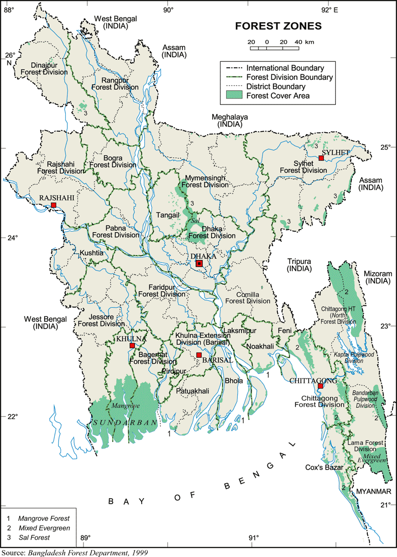
Forests
Forest type
Based on their ecological
characters, the forests of Bangladesh
can be divided into tropical wet evergreen,
tropical semi-evergreen, tropical
moist deciduous, tidal, and planted
forests.
Tropical
wet evergreen forest
Evergreen plants dominate with rich
biodiversity; few semi-evergreen and
deciduous species also occur but do
not change or alter the evergreen
nature of the forests. They occur
in hilly areas of Chittagong, Chittagong
Hill Tracts (CHT), Cox's Bazar in
the SE, and Maulvi Bazar in the NE.
The top canopy trees
reach a height of 45-62 m. Due to
humidity, epiphytic orchids, ferns
and fern allies, climbers, terrestrial
ferns, mosses, aroids, and rattans
are found as undergrowth in moist
shady places. The shrubs, herbs and
grasses are fewer in number.
About 700 species
of flowering plants grow in this type
of forest. Trees like kaligarjan,
dhaligarjan, civit, dhup, kamdeb,
raktan, narkeli, tali, chundul, dhaki
jam are the common evergreen species
which constitute the uppermost canopy.
Champa, banshimul, chapalish, madar
are some of the semi-deciduous and
deciduous trees that grow sporadically.
Pitraj, chalmoogra, dephal, nageswar,
kao, jam, goda, dumur, koroi, dharmara,
tejbhal, gamar, madanmasta, assar,
moose, chatim, toon, bura, ashok,
barmala, dakrum occupy the second
storey. Sometimes Gnetum species and
Podocarpus, two gymnosperms, are met
with. Several species of bamboo are
also found in these forests.
 T
T
Tropical
semi-evergreen forest
Generally evergreen in character but
deciduous plants also dominate. These
forests range in the hilly regions
of Sylhet through Chittagong, the
Chittagong Hill Tracts, Cox's Bazar,
and also in some parts of Dinajpur
district in the NW. Most of them are
subjected to jhum (slash and burn)
cultivation. Over 800 species of flowering
plants have been recorded in these
forests. They have more undergrowth
than evergreen forests. Top canopy
trees reach a height of 25-57 m. In
the valleys and moist slopes chapalish,
telsur, chundul and narkeli constitute
the top canopy; gutgutya, toon, pitraj,
nageswar, uriam, nalizam, godajam,
pitjam, dhakijam form the middle storey;
and dephal and kechuan constitute
the lower storey. On the hotter and
dryer slopes and on ridges different
species of garjan, banshimul, shimul,
shil koroi, chundul, guja batna, kamdeb,
bura gamari, bahera and moose form
the upper storey; gab, udal and shibhadi
form the middle storey and adalia,
barmala, goda, ashoka, jalpai and
darrum constitute the lower storey.
The common deciduous species are garjan,
simul, bansimul, batna, chapalish,
toon, koroi and jalpai. The flora
of these forests resembles those of
eastern Himalayas in the north and
Arakan in the south.
These forests collectively
occupy about 6,40,000 ha of land and
supply about 40% of the commercial
timber of the country. Recent introduction
of rubber plantation along with the
previous exotic teak plantation is
gradually changing the natural character
of the forests.
Tropical moist deciduous forest
Commonly known as sal forest, sal
(Shorea robusta) being the dominant
species. These forests are now distributed
in Dhaka, Mymensingh, Dinajpur and
Comilla regions. They constitute two
distinct belts (covering about 107,000
ha of land); the larger one falls
between the bhramaputra and the jamuna
rivers with a length of about 80 km
and a width of 7-20 km. This part
is known as Madhupur Garh. The other
smaller belt is situated at Sherpur
district and lies along the foothills
of the Garo Hills of India, having
a length of about 60 km and width
of 1.5-10 km. There are some smaller
remnant patches of forest areas in
Rangpur, Dinajpur, Thakurgaon, and
Naogaon districts (covering about
14,000 ha) with some remainings in
Shalvan Vihara, Mainamati and Rajeshpur
in Comilla (about 200 ha).
Until the beginning of the 20th century,
these forests existed as a continuous
belt from Comilla to Darjeeling of
India. At present, most of the forest
area is under occupation and the present
remaining stands of sal are of poor
stocking and quality, consisting of
degraded coppice and plantations.
The present notified area of this
forest is largely honeycombed with
rice fields. The forest forms more
or less a uniform canopy of 10-20
m, mostly with deciduous plants. Other
than the sal (about 90%), the other
common trees are palash, haldu, jarul
or shidah (Lagerstroemia parviflora),
bazna, hargoja, ajuli (Dillenia pentagyna),
bhela, koroi, menda (Litsea monopetala),
kushum, udhal, dephajam, bahera, kurchi,
haritaki, pitraj, sheora, sonalu,
assar, amlaki and adagash (Croton
oblongifolius). Climbers (mostly woody)
like kanchan lata, anigota, kumari
lata, gajpipal, pani lata, Dioscorea
species, satamuli, and gila occur
in these forests. A good number of
undergrowth is also recorded (about
250 species under 50 genera). The
common ones are assam lata, bhat,
boichi, moina kanta and ashal. The
significant rass is sungrass. A few
epiphytes are also recorded. Legumes,
euphrobias and convolvulous plants
also occur.
Tidal forest
The most productive forest
type in Bangladesh, they are situated
in Khulna, Patuakhali, Noakhali and
Chittagong regions along the coastal
region, and constitute about 520,000
ha. The grounds of these forests are
flooded every time at tide with seawater.
The plants have pneumatophores, with
viviparous germination, and are evergreen
in nature. Other than sundari, passur,
gewa, keora, kankra, baen, dhundul,
amoor, and dakur grow gregariously.
Turbidity and salinity of water in
the coastal zones regulate the frequency
and constituent feature of the species.
In addition to the Sundarbans,
many small islands found in the mouth
of Gangetic delta are densely covered
with tidal forests, although the sundari
tree is absent here. The pioneer plant
in the forest quickly develops on
creeks and mudbanks of streams where
deposition of silt is in progress.
Near the streams and canals, rhizophores
(having stilt roots) are common.
There are certain
forests localized to a particular
habitat conditions. These are actually
secondary formations. They include:
(i) The beach or littoral forest-
occurs along the sea beaches of Cox's
Bazar, Chittagong, Barisal and Patuakhali
regions, adjoining to tidal forests.
Jhau, kerung, ponyal, kathbadam, madar,
paras and nishinda are occasionally
associated and form different shades
of thickets. (ii) Fresh water swamp
forest- occurs in low-lying haor (large
water bodies) areas in Sylhet and
Sunamganj and also in depressions
within the hill forest area.
The area is subjected
to flooding during rainy season and
the soil is very moist. In Sylhet
area, the swamp forest is covered
with grasses like ekhra, kaghra, and
nal. Along the bank of haor areas
hijal trees often form a pure stand.
Undergrowth in these forests is mainly
cane, lantana and many large grasses
and sedges. Tree species associated
with savanna are koroi, shimul, kalhuza
(Cordia dichotoma), bhatkur (Vitex
heterophylla), and jarul. The common
undergrowth are tara (Alpinia), costus,
murta, melastoma, and nal. Other than
these specialized forests, there are
some localized forests with distinctive
floristic composition found along
the streams of hilly regions, locally
known as charas. The trees that are
commonly found along this areas are
chalet, pitaly, kanjal (Bischofia
javanica), jarul, ashoka, bhubi (Baccaurea
ramiflora), jalpai, shera and dunus.
Many epiphytes and ferns, and also
mosses are frequently found in the
composition.
In the clear felled
areas of the hill forests, the pioneer
plants that appear in the new plantation
area are fishtail palm, bura (Macaranga
species), barmala (Callicarpa arborea),
chima (Hibiscus macrophyllus), goda
(Vitex peduncularis), jiban (Trema
orientalis), nunkochi (Glochidion
species), amlaki, kurchi, elena (Antidesma),
kodom, depha jam (Cleistocalyx operculata),
koroi, udal, bazna, kanta koshoi,
toon, bhadi, gutgutya (Proteium serratum),
bata, hargaja, and various types of
grasses. Some distinct types of forests
also develop due to gradual elimination
of natural primary forests, and may
be termed as scrap jungle of the savannah
type (about 750,000 ha). These secondary
forests are often burnt to raise sungrass.
Plantation
forest
These are raised forests and are grouped
into two categories: Planted state
forest- Initial attempts to raise
plantation forests started in 1871
with teak at Kaptai in the CHT using
seeds from Myanmar. Since then plantation
forestry has become a part of the
overall clearfelling silviculture
system. Until 1920 it remained confined
to the CHT. Then it was extended to
Chittagong and Sylhet divisions. The
plantation rate per year was about
400 ha. After teak, the other common
introduced plant species are gamar,
chapalish, garjan, mahagoni, jarul,
toon, painkado and jam. In the 1950s
and 1960s wide plantation programmes
were undertaken. In 1974, the Forest
Department started planting fast growing
species like gamar, Albizia falcata,
kadam, Acacia species, Eucalyptus
species and pine on a large scale
to produce fuelwood. Planted private
forest- Traditionally homesteads grow
trees and many other crops in an effective
way. Now this forest type is developing
at a faster rate compared to the rate
of deforestation of state forests.
About 160 species are known to occur
in homestead forests. This forest
has been proved to be highly productive.
Forest distribution
The total forest area in Bangladesh
including unclassed state forest land
is about 2.25 million ha. A large
part of the area, however, has no
tree cover. Over the last three decades
forest cover declined by 2.1 percent
annually. Village groves or village
forests play a very important role
in the economy of the country. These
provide a significant portion of the
wood and firewood supply of the country.
Besides wood production, village forests
have several important uses. They
provide fruit, fodder, fuel, raw material
for small and cottage industries,
house construction materials, agricultural
implements, cart wheel, etc. The area
covered by village groves or forest
is estimated to be about 0.27 million
ha. This is not forest as per definition.
However, in the Bangladesh context
this tree cover is very significant
in many ways.
Tea garden is another category which
needs mention. A good quantity of
tree resources are available within
the tea garden. The tree cover areas
of tea gardens are fast depleting.
Approximately 2800 ha are available
under this kind of tree cover, and
distributed in Chittagong, Sylhet
and Rangamati.
A third category
of forest which is fast emerging are
the plantations on non-forest public
land, such as road side, railway embankment,
and canal banks. This marginal land
plantations in one way are substituting
for the decreasing village forests,
and are adding a new dimension to
fallow land utilization.
The state owned forests
(see table) of Bangladesh are distributed
in three zones: a) Hill forests in
the greater districts of Chittagong,
Chittagong Hill Tracts, and Sylhet;
b) Inland forests in the central and
northern zones; and c) Littoral forests
in the delta and coastal regions.
Status of the state-owned
forest land (in ha)
| Forest type |
Reserve forest |
Protected forest |
Vested forest |
Acquired forest |
BWDB and khas |
Unclassed state
forest |
Total |
| Hill |
594,383 |
32,303 |
2,636 |
11,004 |
-- |
721,344 |
1361,670 |
| Inland |
68,140 |
2,689 |
19,985 |
31,198 |
-- |
-- |
122,012 |
| Littoral |
656,579 |
-- |
-- |
6 |
101,526 |
-- |
758,111 |
| Total |
13,19,102 |
34,992 |
22,621 |
42,208 |
101,526 |
721,344 |
22,41,793 |
The table on state
on forests, however, does not in anyway
imply that the land is under actual
control of the Forest Department.
Much of the land is under the occupation
of encroachers. The encroachment is
quite high in the inland sal forests.
Observations since 1985 indicate that
encroachment and shifting cultivation
is on an increase in the Chittagong
Hill Tracts.
The hill forests occupy more than
half of the forests of the country.
These forests are important from economic
and environment perspectives. The
description given below mostly applies
to the forests of greater Chittagong
Hill Tracts and Chittagong. The forests
of Sylhet are extension of the forests
of Chittagong Hill Tracts and Chittagong.
The major hill reserve forests are
Kassalong (including Maini Head Water
Reserve), Rhankhiang, Sitapahar, Sangu,
Mata Muhuri, Chittagong, Cox's Bazar,
and Sylhet reserve forests. Sitapahar
was the first forest reserve in the
hills and was declared as such in
1875. About the time government appointed
professionals to manage forests. During
the first decade of the last century,
survey and demarcation of most of
the forest areas took place. Forest
department started tree plantations
at Sitapahar in 1871. Thereafter teak
plantation continued on a regular
basis. The clear felling with artificial
planting programme which was introduced
to Sitaphar extended to Kassalang
and Rankhiang reserves. In the mid-sixties
the Forest Industries Development
Corporation was established to conduct
mechanical extractions and up to 1000
ha of forests of Kassalang and Rankhiang
plantations, mainly of teak were raised.
A moderate area of 5,037 ha of plantations
were raised in the Matamuhuri reserves.
The Chittagong Hill
Tracts contains over 700 thousand
ha Unclassed State Forests (USF),
which are subject to shifting cultivation.
A part of USF spreading over Bandarban,
Khagrachari, and Lama has been taken
over by Forest Department and plantations
have been raised there. Up to 1990,
about 48,000 ha of plantations of
teak and other species have been raised.
Inventory of Chittagong and Cox's
Bazar was made in 1987. Out of 52,471
ha of natural forest area about 38%
was found to have small crown secondary
disturbed high forest; 13% good quality
large crown forests, 1% Garjan cover,
and remaining 48% brush with scattered
trees. In the inventory it was further
seen that only 17,862 ha of plantations
out of 38,852 ha of plantations was
raised ie approximately 21,000 ha
of the plantation area was lost. The
loss is attributed to encroachment,
illicit removal, and the ravages of
the World War II (1941-45) and 1971
liberation war.
In Cox's Bazar out
of 24,438 ha of natural forests, 57%
consists of small crowned secondary
disturbed forests, 42% relatively
good quality forests and the remainder
are all disturbed forests. The high
proportion of secondary forest is
a result of large scale selective
harvesting during the war periods.
It was also revealed that out of 38,000
ha of plantations raised in the division
only 24,210 ha survived (1991), ie,
approximately 30% of the plantations
are poorly stocked. Due to recent
mass migration of Rohingyas from adjacent
Myanmar and their camping in the forests
of Cox's Bazar, the condition has
further deteriorated.
Sylhet forest areas
were part of Assam prior to 1947.
Not much of early records about the
forest is available; the inventory,
however, shows that in Sylhet 13,802
ha of plantations exist.
Inland sal forest
The sal forests are presently distributed
in the districts of Dhaka, Tangail,
Mymensingh and Dinajpur. Rangpur,
Rajshahi and Comilla have little denuded
scattered areas of forests. In the
past quite a vast area of Mymensingh,
Tangail and Dhaka was occupied by
sal forests.
The inland sal forests
were under private ownership till
1950. The forest of the central zone
of Bhawal in Gazipur district, and
Atia in Tangail have, however, been
under partial management of Forest
Department under an agreement with
the owner. Until 1917, the owner managed
all the forests. The first management
plan for Bhawal forests appeared in
1917 and for Atia forests in 1934.
After partition in 1947, forest department
divided these forests into two working
circles. One was timber and conversion
working circle where clear felling
followed artificial plantation, keeping
the rotation to 70-80 years, and the
second was coppice working circle,
keeping the rotation to 25 years.
Before 1959, the
forest areas of Dinajpur, Rangpur
and Rajshahi remained under the control
of proprietors. Since there was indiscriminate
felling, the Forest Department prepared
a management plan in this year. The
plan prescribed three working circles:
conversion, coppice and afforestation.
In 1976 the plan was revised to create
two working circles: community forestry
working circle, and commercial working
circle. The plan did not work and
65% of the forest is now highly degraded
or encroached.
The littoral
mangrove forests
There are two tracts of littoral forests.
The smaller one is the chakaria Sundarbans.
It lies in the delta of the matamuhari
river in Cox's Bazar district. It
was declared as Reserved Forest in
the later part of the last century.
Though management plan for the area
existed since 1911, demand for forest
produce and fish culture led to illegal
removal and artificial inundation
of the forest. Bangladesh government
transferred about 3,233 ha of forests
to shrimp cultivation. Uncontrolled
shrimp cultivation and establishment
of seasonal salt beds cleared the
remaining forests.
Sundarbans
in the delta of the Ganges and Brahmaputra
stretches from the Hughly river to
the Rabnabad island, and extends inland,
in places, as far as 160 km. Two-thirds
of the forest area is within Bangladesh.
In the Eighteenth Century, forests
were double their present size. Uncontrolled
deforestation and settlement of land
led to reduction of forest size, and
the the Sundarbans was declared as
a Reserve Forest in 1875. In area
(about 557285 ha) though Sundarbans
remain intact, crops have deteriorated
substantially due to increase in salinity,
top dying of Sundri, and tectonic
movement. Through its own initiative,
the Forest Department has started
a coastal afforestation programme
in the early sixties to create a protective
belt in the coastal offshore and in
the islands having no tree cover.
A substantial extent of plantations
in the coastal regions have been raised
and mini-littoral forests now exist
in the coastal belts.
Present distribution
and area (ha) of different forest
types under different forest divisions
| |
Reserved
forest |
Acquired
forest |
Protected
forest |
Vested
forest |
Unclassed
state forest |
Khas |
Total |
| Hill forest |
5,94,383 |
11,004 |
32,303 |
2,636 |
7,21,344 |
-- |
13,61,670 |
| CHT(North) |
1,59,379 |
-- |
-- |
-- |
1,53,063 |
-- |
3,12,442 |
| CHT(South) |
82,161 |
-- |
-- |
-- |
1,72,721 |
-- |
2,54,882 |
| Bandarban USF |
40,198 |
-- |
-- |
-- |
78,592 |
-- |
1,18,790 |
| Pulpwood Bandarban
|
-- |
-- |
-- |
-- |
58,236 |
-- |
58,236 |
| Lama |
-- |
-- |
-- |
-- |
75,149 |
-- |
75,149 |
| USF Rangamati |
12,801 |
-- |
-- |
-- |
89,694 |
-- |
1,02,495 |
| Jhum Control |
12,903 |
-- |
-- |
-- |
9,600 |
-- |
22,503 |
| Pulpwood Kaptai
|
29,279 |
-- |
-- |
-- |
-- |
-- |
29,279 |
| Khagrachari USF |
1,409 |
-- |
-- |
-- |
82,073 |
-- |
83,482 |
| Chittagong |
82,307 |
5,096 |
19,873 |
2,636 |
-- |
-- |
1,09,912 |
| Cox's Bazar |
1,04,103 |
1,241 |
12,430 |
-- |
-- |
-- |
1,17,774 |
| Sylhet |
69,843 |
4,667 |
-- |
-- |
2,215 |
-- |
76,725 |
| Inland forest |
68,140 |
31,198 |
2,689 |
19,985 |
-- |
-- |
1,22,012 |
| Dhaka |
26,221 |
-- |
-- |
-- |
-- |
-- |
26,221 |
| Tangail |
22,460 |
27,287 |
-- |
-- |
-- |
-- |
49,747 |
| Mymensingh |
13,467 |
-- |
-- |
15,019 |
-- |
-- |
28,486 |
| Dinajpur |
5,037 |
387 |
-- |
4,681 |
-- |
-- |
10,105 |
| Rangpur |
763 |
1,697 |
263 |
-- |
-- |
-- |
2,723 |
| Rajshahi |
192 |
11 |
2,426 |
276 |
-- |
-- |
2,905 |
| Comilla Extn |
-- |
1,696 |
-- |
-- |
-- |
-- |
1,696 |
| Dhaka Extn (south) |
-- |
-- |
-- |
9 |
-- |
-- |
9 |
| Kushtia Extn |
-- |
8 |
-- |
-- |
-- |
-- |
8 |
| Bogra Extn |
-- |
7 |
-- |
-- |
-- |
-- |
7 |
| Faridpur Extn
|
-- |
10 |
-- |
-- |
-- |
-- |
10 |
| Jessore Extn
|
-- |
9 |
-- |
-- |
-- |
-- |
9 |
| Botanical garden,
Dhaka |
-- |
86 |
-- |
-- |
-- |
-- |
86 |
| Littoral forest |
6,56,579 |
6 |
-- |
-- |
-- |
101,526 |
75,811 |
| Sundarbans |
5,57,285 |
-- |
-- |
-- |
-- |
-- |
5,77,285 |
| Bhola CA |
2,236 |
-- |
-- |
-- |
-- |
24,304 |
26,540 |
| Patuakhali CA |
8,571 |
-- |
-- |
-- |
-- |
13,293 |
21,864 |
| Noakhali CA |
35,741 |
6 |
-- |
-- |
-- |
54,618 |
90,365 |
| Chittagong CA |
32,746 |
-- |
-- |
-- |
-- |
9,311 |
42,057 |
| Total |
13,19,102 |
42,208 |
34,992 |
22,621 |
7,21,344 |
1,01,526 |
22,41,793 |
Abbreviations CHT-Chittagong
Hill Tracts, USF- Unclassed State
Forest, Extn-Extension, CA-Coastal
Afforestation includes Matamuhuri
Reserve.
Source: Forestry
Master Plan (Forest Management)
Forest resource
In terms of forest land, the Chittagong
Hill Tracts forest division on the
southeastern border of the country
contributes about 47%, followed by
the Sundarbans and Patuakhali coastal
divisions, about 27%. The northwestern
region, including Dinajpur, Bogra,
Rajshahi and Rangpur districts, has
less than one percent state forestland.
The western region, ie Jessore, Kushtia,
Faridpur and Barisal, has slightly
more than one percent. And yet after
the agriculture sector, forestry is
one of the major economic activities,
contributing to about 3% GDP of the
country.
At least about 1,000
species of forest plants are economically
important; of these about 400 are
considered as tree species and about
450 as medicinally important. About
50 tree species and about 100 shrubs
and herbs are viewed as commercially
important. Bangladesh Forestry sector
consists mainly of the primary production
of forest products. Except pulp, paper
and board mills, the secondary sector
is weakly developed and undercapitalized.
Logs and bamboo, the two main industrial
raw materials, come mostly from private
lands; and also from Government managed
forestlands.
Official records
show that Government forest land produces
about 5,50,000 m3 of roundwood and
about 65 million pieces of bamboo
annually. In 1997, the value of the
forestry sector has been estimated
at Taka 21 billion (US $ 537 million),
80% of which comes from primary, 11%
from secondary round wood processing,
and 3% from non-wood products. Saw-log
production is of the largest single
value, making up to 42% (Tk 9 billion),
while fuelwood production contributes
27% (Tk. 5.8 billion). Bamboo production
is at 13% (Tk 2.9 billion). Solid
wood processing, principally saw milling,
adds about 6%, and pulps and paper
production just over 4% of added value.
Tertiary wood manufacturing production,
mainly furniture and cabinet making,
is responsible for about 1%. Estimated
total present employment is about
8,00,000 persons. However, considering
the seasonal nature of work, people
benefiting directly from forestry
related works would be about 1.3 million.
Fuelwood, after solid wood, is the
next important forest resource. Of
total forest products, about 65% are
consumed as fuelwood. In 1995, total
regulated supply was 6.5 million m3
against the demand of 8.27 million
m3.
Hill forests are
treasure-houses of forest resources.
These forests are classified as subtropical
evergreen forests, semi-evergreen
forests and bamboo forests. The most
abundant but important timber trees
are garjan, teak, chapalish, gamar,
telsur, jam, jarul, civit, raktan,
champa, narkeli, teli, chundul, chikrassia
and koroi.
The next important
natural forest resources are the Sunderbans
forests. Government management of
these forests began in the 1870's
under the system of select felling
and natural regeneration. Subsequently,
in the 1930's a system of clear felling
by plantation appeared. During the
Second World War, these forests were
exploited on a large scale and the
practice continued after independence
in 1947 to meet the rising demand
of forest products. Then management
practice was raised for long (40 years)
and short (20 years) rotation cycles.
Following the establishment of Khulna
Newsprint Mills in 1959 and many other
Khulna based forest industries, the
forest management intensity increased.
Logs, timber, fuelwood and golpata
leaves are major produces of the forests,
and are mostly collected on the basis
of collection permits.
At present, Sal forests
are largely composed of two remnant
tracts. One of them is some 105,000
ha in the districts of Tangail and
Mymensingh. The second, one is the
Barind tract, covering scattered patches
of some 14,000 ha in the northwest
districts. Unlike other areas under
the control of the Forest Department,
these areas were not put under Government
management for a long period, since
they were nationalised in the 1950s.
The present notified Sal forests area
is actually honey-combed with habitations
and rice fields. These forests mainly
supply sal timber and logs along with
many other soft wood and firewood.
Bamboo is the most
important non-wood forest resource
in Bangladesh. Some 10 species occur
naturally in forest, which account
for about 20% of the national stock.
Muli (Melocanna baccifera) is the
most prominent. Forests of Chittagong
and the Chittagong Hill Tracts are
the richest sources of bamboo, followed
by the Sylhet hill forests. The rest
come from village groves distributed
throughout the country.
Non-wood forest resources
as a group, apart from their economic
value, represent the bulk of diversity
in natural forests. The situation
with regard to the management of non-wood
forest products in the natural forests
is far from satisfactory. Hundreds
of items are exploited daily from
the forests by local inhabitants.
Of the thatching and weaving resources,
sungrass is used extensively in rural
areas. The production of sungrass
is about 2 million bundles. It grows
abundantly in the denuded and Savannah
forests, mostly those in the eastern
hilly forests. Leaf of golpata (Nypa
fruticans) of the Sundarbans is an
important thatching material in the
southern districts. The annual production
is about 70,000 m tons. Rattan, an
important resource of hill forests,
is also cultivated as a homestead
plant, and is used for making furniture,
baskets, and a number of fancy articles;
the harvest rate being 1,00,000 running
metres.
Murta, a reed plant,
is used for making sleeping mats,
bags, baskets and many utility items.
It grows in both natural and homestead
forests. Nowadays, inflorescence of
a grass, named phuljharu (Thesalonaena
maxima) used to make brooms is an
economic material of hill forests.
About 500 species of plants having
medicinal properties occur in the
forests of Bangladesh. Depending on
the phytochemical contents, different
parts are collected and used in preparations
of indigenous and folk medical formulations.
There are about 500 Unani and Aurvedic
medicine preparing units in Bangladesh.
Current supply of plant materials
for indigenous medicine is about 800
m tons.
Mangrove forests
of Bangladesh are a home of estuarine
fishes, shrimps and crabs. Some 10,000
m tons of fish is collected from the
Sundarbans area annually. Honey collectors
collect honey and bee-wax from this
forest. Annual honey collection from
the Sundarbans alone is about 150
m tons.
Area under
forest by type of forest
| (Sq.miles)
|
Year
|
WAPDA
& Khash land |
Garden
area |
Reserve
forest |
Acquired
forest |
Vested
forest |
Protected
forests |
Unclassed
state forest |
Total |
%
of total area |
| 1975-76
|
47.75
|
0.33
|
4430
|
365
|
41
|
222
|
3502
|
8608
|
15.48
|
| 1976-77
|
47.75
|
0.33
|
5104
|
365
|
41
|
222
|
3502
|
9282
|
16.70
|
| 1977-78
|
48.00
|
- |
5101
|
367
|
41
|
222
|
3513
|
9292
|
16.71
|
| 1978-79
|
47.80
|
- |
5129
|
341
|
43
|
222
|
3517
|
9299
|
16.73
|
| 1979-80
|
47.80
|
- |
5427
|
346
|
42
|
222
|
3521
|
9606
|
17.28
|
| 1980-81
|
47.80
|
- |
5422
|
399
|
41
|
222
|
3440
|
9572
|
17.22
|
| 1981-82
|
48.00
|
- |
5422
|
397
|
42
|
222
|
3498
|
9629
|
17.32
|
| 1982-83
|
48.00
|
- |
5425
|
311
|
42
|
222
|
1553
|
7601
|
13.67
|
| 1983-84
|
787.29
|
- |
4893
|
306
|
41
|
222
|
1440
|
7689
|
13.83
|
| 1984-85
|
47.80
|
0.34
|
5644
|
268
|
35
|
231
|
1768
|
7994
|
14.38
|
| 1985-86
|
54.71
|
0.34
|
5718
|
262
|
35
|
207
|
2443
|
8720
|
15.68
|
| 1986-87
|
46.15
|
0.34
|
4882
|
361
|
35
|
206
|
1578
|
7108
|
13.40
|
| 1987-88
|
54.70
|
0.34
|
5097
|
447
|
35
|
206
|
6823
|
7420
|
13.45
|
| 1988-89
|
50.00
|
na
|
4353
|
492
|
97
|
193
|
1390
|
7181
|
12.50
|
| 1989-90
|
400.60
|
na
|
5063
|
156
|
87
|
143
|
1313
|
7162
|
12.60
|
| 1990-91
|
369.00
|
na
|
5028
|
157
|
87
|
202
|
1335
|
7178
|
12.81
|
| 1991-92
|
51.00
|
na
|
5092
|
496
|
54
|
197
|
1433
|
7323
|
13.08
|
| 1992-93
|
481.72
|
na
|
4689
|
603
|
31
|
145
|
1417
|
7367
|
13.16
|
| 1993-94
|
151.68
|
na
|
5109
|
515
|
32
|
193
|
1371
|
7371
|
13.16
|
| 1994-95
|
272.55
|
na
|
5643
|
372
|
33
|
149
|
1840
|
8461
|
13.60
|
| 1995-96
|
272.55
|
na
|
5643
|
372
|
33
|
149
|
1840
|
8461
|
13.60
|
| 2002-03
|
92.99
|
na
|
6996
|
33
|
15
|
143
|
2749
|
10028
|
17.50
|
| Source:
Department of Forest |
Forest product
Considering forest habitats, forest
products are of two types: (i) Land
forest products; and (ii) Littoral
forest products. These can further
be categorised as non-timber, and
timber forest products.
Among the various
uses of the forest products mention
may be made about the following:
House construction
and building materials. Both sawn
wood and round timber as well as bamboo
are used. Assuming the economic life
of the house to be 25 years, the consumption
per capita/annum is 0.0068 m3 for
building construction.
Furniture and fixtures
Numerous items are included in the
furniture and fixture categories.
The adjusted weight average is 0.0664
m3 per capita for the life of the
furniture. Per capita consumption
is 0.0026 m3/annum when the economic
life of the furniture is considered
to be 25 years.
Transport equipment
Wood is the main component for making
almost all rural transports including
bullock cart, buffalo cart, boat,
rickshaw, carriage van, hackney carriage,
palanquin (Palki), and duli. Wood
has also been used for making modern
mechanized transports like bus, truck,
launch and ship. The adjusted weight
average is 0.00721 m3 per capita.
Considering the economic life of the
transport equipment to be 20 years,
the annual per capita consumption
is 0.00036 m3.
Agricultural implements
Traditional agricultural implements
include various equipment and tools
which are made from wood. The adjusted
weight average is 0.0276 m3. Assuming
the economic life of agricultural
implements to be 20 years, per capita
consumption is 0.0014 m3/annum.
Pulp, paper and newsprint
Among forest based industries, pulp,
newsprint and paper manufacturing
occupy dominant positions. There are
three paper mills: the Karnafuli Paper
Mill (KPM), North Bengal Paper Mill
(NBPM) and Sonali Paper and Board
Mills Ltd. All these mills manufacture
industrial grade papers and paperboard.
There is only one newsprint mill located
at Khulna. Except NBPM, all paper
mills consume wood and/or bamboo pulp
for their production.
Wood-based panel
products These include a wide variety
of semi-finished and intermediate
wood-products like hard board, particle
board, plain wood text, veneer board,
plywood tea chests, flash doors, windows,
etc made by using wood (and wood by-product
such as saw dust). Both private and
public sector enterprises are engaged
in the production of panel products.
Annual average requirement of saw-log
in these units is about 97 thousand
m3.
Fuel and firewood
More than 80% of the total fuel and
firewood are procured from forests.
Of the total fuel wood, nearly 85%
is used in rural areas and 15% in
urban areas. Besides fuel wood, almost
all firewood are used for small industries
like brick fields. The estimated national
demand for fuel wood is about 7975.49
thousand m3.
Rubber products Rubber
is a monotype forest product. Bangladesh
has a good number of rubber gardens
in Chittagong, Sylhet and Madhupur
areas. The production of Rubber in
Bangladesh was 2966.58 and 3101.21
thousand kg in 1997-98 and 1998-99
respectively.
Other miscellaneous wood and forest
products Among miscellaneous wood
products, match manufacturing occupies
a prominent place. Other major items
include pencil, slate and scale production,
toy manufacturing, electrical and
telephone poles, textile and jute
mill spares and accessories, etc.
In addition, some handicraft items
are manufactured from some forest-based
small industries. Golpata (Nypa fruticans),
collected from the Sundarbans, is
used for roofing.
Non-timber forest
product Many small industries, private
and government handicrafts and cottage
industries are based on non-timber
forest materials. Many of the products
are exported to different countries.
A good number of craftsmen are employed
in these industries. Some of the most
important non-timber plants and plant-products
include bamboo (for making houses,
furniture and souvenir items), rattan
or cane (for making furniture and
luxury souvenir items), sungrass (for
house roofing/thatching), pati pata
and hogla (for floor mats), nipa palm
or golpata (for thatching and roofing),
forest honey (mainly from the Sundarbans),
Gewa (raw materials of Khulna Paper
Mill for producing newsprint), and
medicinal plants (eg Amlaki, Bohera,
Horitaki, Swarpagandha, Kurchi, Arjun,
Basok, Swatamuli, Akanda, Dumur, Ulat-chandal,
Anantamul, Tulshi, Nisindha etc).
Forest management
No scientific attempt was made anywhere
in the subcontinent to conserve the
forests before the advent of British
rule. Even in the early days of British
rule, there was much wasteful exploitation
of forests to meet the requirements
of the people. In 1862, on his way
to Delhi from Burma (Myanmar), Brandis
inspected a part of the forests of
Bengal and made a note of the state
of the forests resources of this region.
This marked the beginning of forest
management of Bangladesh. In 1864,
Anderson, Superintendent of Calcutta
Botanical Garden, was appointed as
the First Conservator of Forests of
the Lower Provinces of Bengal and
Assam (now a part of it is in Bangladesh).
Preliminary investigations and enquiries
started by him led to the reservation
of forest areas. In 1871, about 14,685
sq km of hill forests were declared
Government forests. In 1875, the first
forest reserves were declared. The
first forest reserves were in Sitapahar
(currently under Chittagong Hill Tracts
South Division) and in the Sundarbans.
The first management
plan in Bengal was prepared for the
Sundarbans (tidal forests) in 1892.
A management plan for Hill forests
was prepared at the beginning of the
20th century. The management plan
of sal forests was prepared much later.
With the partition
of India in 1947, eastern and northeastern
part of hill forests and unclassed
state forests of Bengal, some parts
of Assam, plainland sal forests, and
most of the Sundarbans forests fell
within East Pakistan. Plantation of
valuable species and extraction of
timber were the main stay of management
practices. Forest Industries Development
Corporation was set up in the early
sixties in an effort to extract timber
from the most inaccessible areas.
The target of plantations was raised
from a few hundred hectares to 4,000
hectares in the mid-sixties. A number
of economic crops like rubber, cashewnut
etc, were also introduced. In the
late sixties, coastal plantations
were also started in the new accretions
of the bay of bengal. The National
Forest Policy of Bangladesh was formulated
in 1979.
Forest management
situation
The Hill Forests are managed under
the clear felling system followed
by artificial regeneration with valuable
species with a rotation of 60 years
(long rotation) and 30 years (short
rotation). The bamboo appears either
as pure stand or as understorey.
The inland sal forests
are managed under coppice system with
a rotation of 25 years. Areas where
Sal (Shorea robusta) trees are comparatively
fewer are managed under clear felling
system followed by artificial regeneration
mostly with Sal and other suitable
species.
The tidal forests
are managed under selection system
followed by natural regeneration with
a felling cycle of 20 years. Afforestation
of coastal lands, offshore islands
and new formations has been undertaken
in the last three decades with mangrove
and other suitable species.
Forest management planning Hill forests-
(i) to convert the existing irregular
forests into regular ones replacing
non-economic trees by valuable and
fast-growing species; (ii) to prevent
denudation in the hills and erosion
of the soil and silting up of rivers;
(iii) to afforest barren areas with
a view to increasing the forest wealth;
(iv) to preserve and propagate wildlife;
and (v) to derive maximum economic
benefits under the principles of sustained
yield in practice.
Tidal forests- (i)
maintenance of the forest stand and
its gradual conversion into regular
selection forests with a balanced
distribution of age classes; (ii)
to afforest newly accreted lands in
an effort to reclaim land; and (iii)
to maintain a sustained supply of
timber, firewood, pulpwood, thatching
materials, and other minor forest
produces for local people and existing
industries.
Inland sal forests-
(i) to bring scientific management
and gradual conversion of the irregular
forest into a series of age classes;
(ii) to supply large sized house posts
and firewood; and (iii) to create
recreational facilities. [Syed Salamat
Ali]
Forest policies
and acts
The National Forest
Policy of 1894 provides the basic
guidelines for the formulation of
acts and rules for the management
of forests in the country. The earliest
attempt to enunciate the need of conserving
forest resources was made in 1855
by the government of British India
through the promulgation of the Charter
of Indian Forests. Prior to this charter
there were only scanty regulations
regarding the felling of trees for
revenue.
The first formal
Forest Policy that was declared in
1894 included the following features:
(1) State forests are to be administered
for public benefit at large, through
regulations of rights and privileges
of the people near the forest. (2)
Forests were categorized as (a) Hill
forests/Protection forests, (b) Economically
important/Production forests, (c)
Minor forests, and (d) Pastureland.
(3) Forests situated on hill slopes
should be conserved to protect the
cultivated plains situated downstream.
(4) Valuable forests should be managed
to yield state revenue. (5) Land suitable
for cultivation within the forest
should be made available for cultivation,
provided that such conversions did
not harm forests and were permanent
in nature. (6) Local population should
be allowed to exercise grazing rights
in low yielding forests.
After the partition
of India in 1947, the policy was not
relevant for the new state of Pakistan
which inherited forest cover for less
than 2% of its territory. The existing
policy neither contemplated the increase
of forest area nor emphasized sustained
harvest from existing forests. Furthermore,
it excluded private forests from its
ambit. These deficiencies were recognized
in the Pakistan Forestry Conference
held in 1949. The conference guidelines
provided improvement upon the Policy
Statement of 1894 and a new Forest
Policy was announced in 1955.
The Forest Policy
of 1955 was further revised and the
Forest Policy of 1962 was introduced.
The Forest Policy of 1955 and 1962
laid emphasis on the exploitation
of forest produce, particularly from
East Pakistan. The policies did not
help the development of forestry in
Bangladesh and were not very favourable
for all round growth of forestry.
In addition, increase in population
and increased demand for food and
other essentials resulted in heavy
pressure on forestland, leading to
ecological degradation. Even though
Bangladesh became independent in 1971,
its National Forest Policy was not
announced until 1979.
The policy statement
of 1979 is very general and vague.
Most of the crucial aspects such as
functional classification and use
of forest land, role of forest as
the ecological foundation of sustainable
biological productivity, community
participation in forestry, etc did
not get any mention in the policy
statement. Consequently, the government
decided to amend the Forest Policy
of 1979. The amended Forest Policy,
known as Forest Policy, 1994, was
approved by the government on 31 May
1995. Following were taken into consideration
while revising the forest policy:
the clauses of public utility as mentioned
in the constitution; the role of forests
in the socio-economic development
of the country, including the environment;
adoption of national policy regarding
agriculture, industry, cottage industry
and other sectors; and the treaties,
protocols and conventions related
to environment and forests.
In the early 1990s,
a 20-year Forestry Sector Master Plan
(FSMP, 1993-2012) was developed, which
aims to bring 20% of the country's
land area under tree cover. It has
three major investment programs: (a)
forest production and management;
(b) wood-based industries; and (c)
participatory forestry. Of the two
scenarios in the FSMP, the High Development
Scenario envisages an investment of
about US $2 billion in the forestry
sector.
The latest Forest
Policy (1994) viewed equitable distribution
of benefits among the people, especially
those whose livelihood depend on trees
and forests; and people's participation
in afforestation programmes and incorporation
of people's opinions and suggestions
in the planning and decision-making
process.
The people-centred
objectives of the policy are: creation
of rural employment opportunities
and expansion of forest-based rural
development sectors; and prevention
of illegal occupation of forest lands
and other forest offences through
people's participation. The policy
statements envisage: massive afforestation
on marginal public lands through partnerships
with local people and NGOs; afforestation
of denuded/encroached reserved forests
with an agroforestry model through
participation of people and NGOs;
giving ownership of a certain amount
of land to the tribal people through
forest settlement processes; strengthening
of the Forest Department and creation
of a new Department of Social Forestry;
strengthening of educational, training
and research facilities; and amendment
of laws, rules and regulations relating
to the forestry sector and if necessary,
promulgation of new laws and rules.
Thus, over time the policy has shifted
somewhat from total state control
to a management regime involving local
communities in specific categories
of forests.
Acts Forest legislation
in Bangladesh dates back to 1865,
when the first Indian Forest Act was
enacted. It provided for protection
of tree, prevention of fires, prohibition
of cultivation, and grazing in forest
areas. Until a comprehensive Indian
Forest Act was formulated in 1927,
several acts and amendments covering
forest administration in British India
were enacted and were as follows:
(a) Indian Forest Act, 1873; (b) Forest
Act, 1890; (c) Amending Act, 1891;
(d) Indian Forest (Amendment) Act,
1901; (e) Indian Forest (Amendment)
Act, 1911; (f) Repealing and Amending
Act, 1914; (g) Indian Forest Amendment
Act, 1918; and (h) Devolution Act,
1920.
The Forest Act of
1927, as amended with its related
rules and regulations, is still the
basic law governing forests in Bangladesh.
The emphasis of the Act is on the
protection of reserved forest. Some
important features of the Act are:
(i) Under the purview of the Forest
Act, all rights or claims over forestlands
have been settled at the time of the
reservation. The Act prohibits the
grant of any new rights of any kind
to individuals or communities; (ii)
Any activity within the forest reserves
is prohibited, unless permitted by
the Forest Department; (iii) Most
of the violations may result in court
cases where the minimum fine is Taka
2,000 and/or two month's rigorous
imprisonment; and (iv) The Act empowers
the Forest Department to regulate
the use of water-courses within Reserve
Forests.
An amendment of the
Forest Act of 1927 was drafted in
1987 and approved in 1989, as the
Forest (Amendment) Ordinance 1989.
The Forest Act was further amended
in 2000 and renamed as the Forest
(Amendment) Act, 2000. Under this
amendment some major changes have
been brought in the Act.
For assuming control
of private forests and wastelands
by the government in the interest
of conservation, the Bengal Private
Forest Act, 1945 was passed; but partition
of India in 1947 intervened and the
Act could not be put into effect.
After partition, in 1949, East Pakistan
reenacted the provisions of the Bengal
Private Forest Act. This was passed
in 1959 as The East Pakistan Private
Forest Ordinance. The private forest
and wastelands taken over by the government
were to be managed as a distinct legal
category, ie, vested forests. The
ordinance had 64 clauses and detailed
provisions for the management and
protection of vested forests. Vested
forests were taken over by the government
from their private owners for a period
of one hundred years for the purpose
of conservation and afforestation,
since they were not being cultivated
properly by their owners.
Degradation:
forest resources Degradation of forests
and their resources have been occurring
due to manifold reasons. Among others,
principal causes of forest destruction
include uncontrolled deforestation,
new settlements, illegal wood cutting
and felling, leaf-litter collection,
dependency on forests for fuel wood,
grazing and browsing, intentional
forest burning, 'Jhum' or shifting
cultivation, conversion of forest
lands into agricultural land, overexploitation
of particular economically important
species such as medicinal, fodder,
dye, etc, indiscriminate use of forest
wood in brick fields and in other
small industries, and total clearing
of undergrowth and excess consumption
of forest materials for domestic purposes.
In addition, heavy rainfall, occasional
landslide, erosion, flood, cyclone
and tornado, increase of salinity,
and some diseases (eg top dying disease
in the Sundarbans) are also major
causes for forest lands and forest
resources degradation.
Moreover, lack of
proper management and awareness, inadequate
research and developmental programme
on habitat and resource and regeneration,
restoration and conservation are also
some additional reasons for the degradation
of forest resources in Bangladesh.
Sometimes the rate
and pattern of forest degradation
vary with the type of forests and
their geographical location. For example,
sal forests of Bangladesh are located
in the middle and northern part of
the country, which are topographically
almost plain lands, and dry in nature.
Owing to geographical position and
edaphic conditions, the scope and
the rate of degradation in sal forests
are higher due to easy encroachment
and illegal settlements.
Pests and diseases
of forest trees Pests- Larva of the
moth, Agrotis ipsilon, known as cutworm,
commonly feeds on seedlings of a number
of forest plants. They hide in burrows
3-8 cm deep in the soil during the
day and come out to the surface at
night. The stems of young seedlings
are cut down at ground level but occasionally
buds or new leaves are also cut. Cockchafer
or white grubs of the beetles Leucopholis,
Holotrichia, and Anomala sometimes
cause serious damage to seedlings
of teak, rubber, babul, jarul, minjiri,
etc. The larva feeds on small roots
and sometimes cut tap root at 5-10
cm below the soil surface. The infested
seedling wilts and ultimately dries
up.
The adult feeds on
the foliage of many trees.
Some termites, including
species of Odontotermes and Microcerotermes
attack young seedlings, saplings,
implants or cuttings in nurseries
and plantations of many forest trees.
Termite attack occurs below the ground
level in the upper 20 cm of the soil
layer. Usually the bark of the tap
root is completely eaten up. The affected
seedlings/young plants show signs
of wilting, resulting in death.
Teak is attacked
by two major lepidopteran defoliators.
These are Hyblaea puera and Eutectona
machaeralis. The mature larvae of
the former consume the entire leaf,
leaving only the mid-ribs and major
veins. On the other hand, the larvae
of E. machaeralis consume only the
green layer of leaf leaving all the
veins intact, thereby skeletonising
the leaf which later turns brown and
dries up.
The young larvae
of gamar defoliator, Calopepla leayana
(Chrysomelidae: Coleoptera) feed mainly
on the undersurface of gamar (Gmelina
arborea) leaves, leaving only the
mid-ribs and main veins intact. The
adult beetle feeds on the leaf, cutting
large circular holes, and also eats
young buds and shoots. Mahogany shoot
borer, Hypsipyla robusta (Pyralidae:
Lepidoptera) is an important pest
of mahogany, toon (Toona ciliala)
and chickrassy (Chukussia tabularis).
The larva bores into the shoots of
the young trees.
Widespread mortality
of Babla (Acacia species) is caused
by the scale insect, Anomalococcus
indicus (Homoptera). The insect sucks
sap from the tender shoots and branches.
In case of heavy infestation, the
shoot is completely encrusted with
the scale insect. The attack is more
severe during November-April.
The larva of Ommatolapus
haemorrhoidalis (Curculionidae: Coleoptera),
commonly known as cane top shoot borer,
bores into the growing shoot of cane.
The larva makes a central tunnel inside
the shoot to feed on the soft internal
tissue.
Koroi (A1bizia species)
is frequently attacked by two major
defoliators, Eurema blanda and E.
hecabe. The young caterpillars nibble
leaflets and as they grow older, they
start eating entire leaflets, leaving
behind only the mid-ribs. In severe
attacks the plants are completely
defoliated. Young plants are mostly
preferred, but older trees are not
spared.
Diseases Dieback
of keora is a serious disease of keora
seedlings. The first symptom appears
as a rot from the tip, middle, or
lower tender portion of the stem.
Affected seedlings decay out from
the top. The disease is caused by
the fungus, Chaetomella raphigera.
Bamboo blight disease
often causes severe mortality of young
bamboo culm. It has been observed
in the country for the last two decades,
and is most prevalent in greater Rajshahi,
Chittagong, Comilla and Sylhet districts
in decreasing order of occurrence.
Bambusa balcooa and B. vulgaris are
the most affected bamboo species of
Bangladesh. The causal fungus has
been identified as Sarocladium oryzae.
Over the last few
decades, a root rot causing dieback
of Lohakat (Xylia oxlocarpa) has been
observed in some plantations in and
around Lawachara of Maulvi Bazar district.
The first symptom is the appearance
of pale green colour of the foliage
of one or more major branches. Later,
the foliage becomes yellow, and eventually
falls off.
Recently a disease,
called pink disease, caused by Corticium
salmonicolor, has been recorded on
Eucalyptus in some plantations of
Chittagong, Cox's Bazar, and Sylhet
Forest Divisions. The most striking
feature of the disease is the mortality
of the major branches accompanied
by leaf cast due to invasion of the
pathogen, which in severe cases may
spread to the crown. The first symptom
appears as an exudation of gum on
the stem or branches, followed by
a growth of white silky threads on
the surface of bark. [M Wahed Baksha]
Forest Department
a Department of the Ministry of Environment
and Forest, and is headquartered at
Mohakhali, Dhaka. A Chief Conservator
of Forests, assisted by three Deputy
Chief Conservators, heads the agency.
It is responsible for forest development
and management planning and forest
extension. The Department has a number
of institutes under its administration
and supervision and these include
a Forest Research Institute and a
Forest College at Chittagong, a Forest
Development and Training Institute
at Kaptai, and two Forest Schools,
one at Sylhet and the other at Rajshahi.
The National Botanical Garden located
at Mirpur, Dhaka is also under the
administration of the Department and
this Garden as well as the Rajshahi
Forest School has tissue culture laboratories.
Besides, the Department implements
a good number of projects and some
of such projects being implemented
from 1990s are the Forest Resource
Development Project, Forestry Sector
Project, Coastal Green Belt Project
and Conservation of Biodiversity in
the Sundarbans Project.
The field operations
of the Department are managed through
six Circles and each Circle has several
forest divisions, the total number
of which is 37 in the whole country.
The divisions are divided into several
forest ranges controlled by Forest
Range Officers, under whom there are
Beats under the charge of Beat Officers
of the rank of Forester/ Deputy Rangers.
The Forest Department has introduced
social forestry activities by involving
people to rehabilitate degraded forestland
as well as marginal land. These activities
include woodlot/block plantation,
agroforestry plantation, strip plantation,
rehabilitation of jhumias (tribal
people living on shifting cultivation),
village afforestation, seedling distribution,
nursery development and training.
The Department has
adopted a Resource Information Management
System (RIMS) that helps significantly
in forest development planning and
monitoring of all regular and project
activities. Integrated with the Geographical
Information Systems, the RIMS has
become an important arm of the Forest
Department as a coordinated centre
for data and information on forest
resources and their management in
Bangladesh. The total number of employees
working in the Forest Department is
about 7300 and besides, the Department
employs a large number of labourers
on a casual basis for its field activities.
Forest education
and research Formal education and
training for personnel working in
forest services were not available
in this subcontinent until 1870s.
From 1878, the Government of British
India started training programme of
the recruited foresters to provide
skilled technical manpower in respective
forest territory.
A forest policy was
adopted in 1894, after about 30 years
of establishing the Forest Department
in undivided India. The subject forestry
as science thus started developing
slowly and gradually in the sub-continent
for the purpose of exploitation of
the vast forest resources by the British
Government. With such a background
and interest the British Government
felt the need of promoting Forest
Education and initiating research
facilities in this part of the country.
During 1926 to 1932, the gazetted
officers of the Indian Forest Service
received training at Dehra Dun. In
1937 with the provincialisation of
the forest services, gazetted officers
started getting training since 1938
for provincial forest services.
After creation of
Pakistan, a forest college was established
in Peshawar, West Pakistan to train
gazetted and non-gezatted forest officers
recruited by the Public Service Commission.
A Forest College was established at
Solasahar in Chittagong for providing
two years diploma course in forestry
for the non-gazetted range officer
recruits of the government, autonomous
and private sector enterpreneurs.
The Institute of
Forestry was established at the Chittagong
University campus in 1976. The institute
offers four-year undergraduate courses
and one-year masters course.
In 1955, a forest
research laboratory named as 'Forest
Product Laboratories' was established
in Chittagong aiming for better utilization
and innovations in this sector. Subsequently
in 1968 it was converted into a full-fledged
Forest Research Institute. The mandate
of the Bangladesh Forest Research
Institute (BFRI) is to conduct research
on the problems faced by and programmes
undertaken by the Department of Forests,
bangladesh forest industries development
corporation (BFIDC) and other concerned
government and non-government organisations.
Source: Banglapedia,
National Encyclopedia of Bangladesh
Asiatic Society of Bangladesh