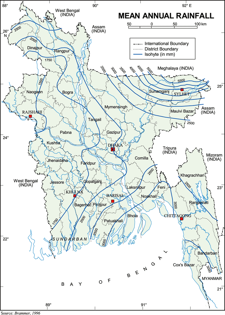
Rainfall
The country belongs
to sub-tropical regions where monsoon
weather prevails throughout the year.
The average temperature ranges from
7.20C to 12.80C during winter and
23.9 to 31.10C during summer. The
average annual rainfall varies from
1229 to 4338 mm (WARPO, 2000). The
total precipitation in the dry regions
is low but the rainfall often occurs
in sudden heavy storms, which sometimes
lead to flooding and soil erosion.

Rainfall is observed
at 327 stations in the country, 31
by BMD and 296 by BWDB. The observation
have been collected from both organizations
and entered on the NWRD. Rainfall
(R) is based on the monthly averages
for a standard 30-year period. Dependable
rainfall (DR) is the rainfall that
is exceeded four years out of five
for any month. Evapotranspiration
(ETo) is the evapotranspiration from
grass. Data for estimating ETo has
been collected at 30 stations since
about 1960 and entered on the NWRD.
The pattern of rainfall
excess and deficit, the difference
between rainfall or dependable rainfall
(DR) and reference crop ETo (in mm)
is tabulated by season and by the
hydrological region. The annual dependable
rainfall exceeds the reference ETo
except in the NW and SW hydrological
region. Rainfall (in mm) in Bangladesh
by hydrological region is given in
Table 1.
Table
1 Rainfall (in mm) by Hydrological Region
|
Hydrological
Region |
Rainfall
|
Dependable Rainfall
(DR) |
Evapotranspiration
(ETo) |
|
South East SE |
2271 |
1746 |
1275 |
|
North West NW |
1739 |
1332 |
1332 |
|
North Central NC
|
1956 |
1529 |
1316 |
|
Rivers & Estuary
RE |
2318 |
1810 |
1325 |
|
South West SW |
1665 |
1259 |
1381 |
|
North East NE |
3194 |
2595 |
1233 |
|
South Central SC |
2307 |
1793
|
1287
|
|
Eastern Hills EH
|
2445 |
1733 |
1360 |
|
Bangladesh |
2360 |
1725 |
1320 |
|
MPO 1991 |
|
|
1553 |
P = Rainfall; DR= Dependable
Rainfall; ETo= Evavotranspiration
Source: WARPO, 2000
Seasonal
Balance of Rainfall and Potential Evapotranspiration
is given in Table 2.
Table 2: Contribution
Seasonal Balance of Rainfall and Potential
Evapotranspiration (in mm)
|
Hydrological
Region |
Monsoon
June-October |
Dry
Season (November -May) |
| R
|
DR
|
ETo
|
R-
ETo |
DR- |
R
|
DR
|
ETo
|
R-ETo
|
DR- |
|
|
|
|
|
ETo
|
|
|
|
|
ETo |
| SE
|
1909 |
1161 |
551 |
1358 |
610
|
588 |
200 |
724 |
136 |
524 |
| NW
|
1539 |
852 |
581 |
958 |
271
|
346 |
131 |
751 |
405 |
620 |
| NC
|
1550 |
901 |
568 |
982 |
333
|
511 |
206 |
748 |
237 |
542 |
| RE
|
1972 |
1169 |
564 |
1408 |
605
|
516 |
174 |
761 |
245 |
587 |
| SW
|
1469 |
872 |
572 |
897 |
300
|
365 |
101 |
809 |
444 |
708 |
| NE
|
2511 |
1535 |
534 |
1977 |
1001
|
896 |
417 |
699 |
197 |
282 |
| SC
|
2016 |
1222 |
537 |
1479 |
685
|
485 |
144 |
750 |
265 |
606 |
| EH
|
2241 |
1280 |
566 |
1675 |
714
|
512 |
148 |
794 |
282 |
646 |
| Bangladesh
|
1901 |
1124 |
559 |
1342 |
865
|
527 |
140 |
759 |
227 |
564 |
P = Rainfall; DR= Dependable
Rainfall; ETo= Evavotranspiration
Source: WARPO, 2000
During the dry season
(of 7 months) in some regions the evapotranspiration
exceeded the amount of rainfall by an
amount of more than 0.5 times the rainfall.
They are Northwest, Southwest, North Central
and South Central Hydrological regions.
So, for that duration within a year these
regions may be considered as dry region.
Seasonal variation of rainfall and Evapotranspiration
contributes to the Rainfall/ ETo as is
shown in Table 3.
Table 3: Contribution
of Seasonal Variation of Rainfall and
Evapotranspiration
| Hydrological
Region |
Rainfall/
ETo(Year) |
P/
ETo Monsoon 5-Months |
P/
EToDrySeason 7-months |
Dependable
Rainfall/ ETo (Year) |
P/
ETo Monsoon 5-months |
P/
EToDry Season 7- months |
| South
East SE |
1.78 |
3.46 |
0.81 |
1.37 |
2.11 |
0.28 |
| North
West NW |
1.30 |
2.65 |
0.46 |
1.00 |
1.47 |
0.17 |
| North
Central NC |
1.49 |
2.73
|
0.68 |
1.16 |
1.59 |
0.27 |
| Rivers
& Estuary RE |
1.75 |
3.50 |
0.68 |
1.37 |
2.07 |
0.23 |
| South
West SW |
1.20 |
2.57 |
0.45 |
0.91 |
1.52 |
0.12 |
| North
East NE |
2.59 |
4.70 |
1.28 |
2.02 |
2.87 |
0.60 |
| South
Central SC |
1.79 |
3.78 |
0.64
|
1.39 |
2.27 |
0.19 |
| Eastern
Hills EH |
1.80 |
3.96 |
0.64 |
1.27 |
2.26 |
0.19 |
| Bangladesh
|
1.79 |
3.40 |
0.69 |
1.31 |
2.01 |
0.18 |
Delineating Dry Regions of Bangladesh
Attempts were made to
identify the aridity in Bangladesh using
meteorological data. It was observed that
Bangladesh does not fall within the annual
aridity limit of 20 according to Martonne
Indices. however, if the monthly data
were used seasonal aridity could be observed.
The seasonal aridity increases from 4
months (November-February) in the northeast/
southeast regions to 6 months (November-April)
in the northwest region. WARPO advocates
dry month periods of 7- month duration
(November - May).
On the basis of annual
rainfall frequency of rainfall (25mm,
50 mm), maximum, minimum and frequency
of temperature (250C, 300C and 350C),
clear days, cloudy sky and first available
rain of the season, Bangladesh has been
divided into 7 seven agro climatic zones.
Out of these, the zones E, F and G possibly
be considered as relatively dry zones.
These would be part of the agro ecological
zones of the Barind and Madhupur Tract
and the Ganges Floodplains.
Occurrence of rainfall
in the Barind area has been analysed to
compare the amount and distribution during
1975-93 with those of the period 1902-74.
The mean annual rainfall of the Barind
Area has changed from 1374.6 mm in the
past (1902-74) to 1491.1 mm in recent
areas. There are incidences of no change
and even a decrease in rainfall southwestern,
southeastern and western parts. The Monsoon
season (June- October) received 83.3%
of the mean annual rainfall. The pre-monsoon
season of March- May received 14.3% (213.1
mm) while the bone-dry season of November-
February got only 2.4% (35.2 mm).
Although the mean annual
rainfall in this area has gone up in recent
years, the increase has almost entirely
been occurred during the monsoon (1278.5
mm vs. 1389.4 mm). The rainfall in the
dry months, when it is really needed,
remained the same (101.2 mm in the recent
years vs. 96.1 mm in the past).
According to the data
registered by BWDB, the annual evaporation
of the area ranges from 370 mm to 1120
mm. The ratio of annual rainfall to evaporation
for this area is 1.33 but considering
the dry months the ratio of rainfall to
evaporation would be 0.18. According to
the Length of Growing Period (LGP) concept
advocated by FAO, areas with an LGP of
less than 1 day are hyperarid (true deserts);
less than 75 days arid, 75 to less than
120 days (dry) semiarid, 120 to less than
180 days (moist) semiarid. These areas
together correspond closely to the areas
denominated as Drylands. The length of
the rainfed growing season ranges from
170-180 days in the west- central west
to 280- 290 days in the extreme north
east.
The humid climatic situation
due to monsoon rainfall, regular flooding
and 170-290 days of annual growth period
are viewed as conditions where desertification
is unlikely to occur where as advocated
in favour of desertification using the
term synonymously with land degradation.
Considering the lower rainfall and its
distribution areas lying west of the longitudinal
line of 89.5 0 E might be described as
dry regions of Bangladesh. A region that
has annual average rainfall much lower
than the national average of 2200 mm may
be considered a vulnerable area for occurrence
of drought and land degradation.
According to the criteria
set by the CCD for defining a dry region
the ratio of annual rainfall to potential
evapotranspiration may be a maximum of
0.65. Taking into consideration of annual
rainfall and corresponding evapotranspiration
data no region within Bangladesh can be
termed as part of dry region. But Bangladesh
experiences long spell of dry months (7
months) and moderate to severe droughts
are spread over a region of 5.46 M ha.
Since Bangladesh has two distinct periods
of Dry season and the Monsoon having duration
of seven and five months respectively,
seasonal influence may be given emphasis
in outlining dry regions. The value of
the ratio of annual rainfall to potential
evapotranspiration (a maximum of 0.65)
may be extrapolated for dry seasons and
used to delineate a dry region. For a
spell of 7-month dry season, the threshold
may be approximated to 0.38. For example,
though the R/ETo values in favour of the
SW and SE hydrological regions for the
whole year is much above the threshold
value of 0.65, the same for the dry period
(of 7 months) is in the range of 0.17-0.45.
These two regions also have the least
annual rainfall and falls within the moderate
to severely affected area of the Drought
Map of Bangladesh.
Considering the distribution
of rainfall and evapotranspiration regimes
and the drought condition in the country,
it is proposed that the regions fulfilling
the following conditions may comprise
dry regions in Bangladesh. The conditions
are:
(i) annual rainfall should
be less than 2000 mm;
(ii) dry season (November
– May) Excess Evapotranspiration
(ETo-R) should be more than 400 mm; and
(iii) dry season R/
ETo ratio value should be less than 0.65.
With this assumption
made and applied on the rainfall and evapotranspiration
data available for the agro ecological
zones of Bangladesh, the Northwest, Southwest
and North central zones can be considered
as dry region of the country. It may be
seen that the drier agro climatic zones
E, F, G falls into the dry regions as
defined above. It is further proposed
that the dry regions may be divided into
two sub regions on the basis of severity
of dryness as shown on Table 4.
Table 4: Severity of Dry Regions
| Severity
|
Conditions/
Criteria Defined |
| Moderate
|
Annual Rainfall
less than 1600 mm |
| Dry season
(November-May) Excess Evapotranspiration
more than 400 mm (ETo- R) - |
| Dry season
(November-May) R/ ETo ratio value
less than 0.4 |
| Slight
|
Annual Rainfall
1600-2000 mm |
| Dry season
(November-May) Excess Evapotranspiration
200-400 mm (ETo- R) - |
| Dry season
(November-May) R/ EToratio value 0.4
- 0.65 |
| Non
dry |
Annual Rainfall
more than 2000 mm |
| Dry season
(November-May) Excess Evapotranspiration
less than 200 mm (ETo- R)– |
| Dry season
(November-May) R/ ETo ratio value
more than 0.65 |
The Rivers and Estuary
hydrological region; the coastal region
and the Sunderbans are considered as non-dry.
The dry map of Bangladesh shows that the
dry zones are extended over an area of
6.442 M ha. The extent of the dry zones
are given in the Table 5.
Table 5: Extent
of Dry Zones of Bangladesh
| Dry
Zones |
No.
of Thanas Occupied |
Area
covered (M ha) |
Percent
of total land |
| Moderate
|
64
|
2.015
|
14.37
|
| Slight
|
163
|
4.427
|
31.56
|
| Nondry
|
263
|
7.585
|
54.07
|
Rainfall
Trends in North East region of Bangladesh
Climate Change in Asia: Bangladesh Report,
Regional Study on Global Environmental
Issues, ADB
Rainfall
Trends in North West region of Bangladesh
Climate Change in Asia: Bangladesh Report,
Regional Study on Global Environmental
Issues, ADB
Rainfall
Trends in South East region of Bangladesh
Climate Change in Asia: Bangladesh Report,
Regional Study on Global Environmental
Issues, ADB
Rainfall
Trends in South West region of Bangladesh
Climate Change in Asia: Bangladesh Report,
Regional Study on Global Environmental
Issues, ADB
|