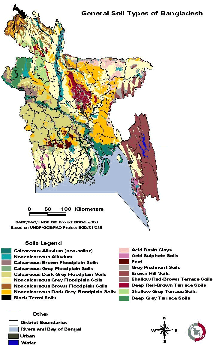
Terrace Soils
Terrace soils are usually found at
Barind Tracts (level Barind Tract,
High Barind Tract and Northeastern
Barind Tract) and Madhupur tracts.
Barind Tract
The Barind Tract
is located in the centre and west
of Rajshahi Division covering an area
of 7,728 km2. It occupies one fourth
of the entire Rajshahi Division. The
Barind Tract represents a series of
uplifted blocks of Madhupur Clay.
It has a low content of weatherable
sand minerals. The greater part of
the tract is almost level and is crossed
by only a few minor rivers. The little
Jamuna and Atrai flood plains occupy
fault troughs which divide the tract
into three main blocks.
The western side
of the western block has been tilted
up to the west and subsequently dissected
by valleys. Most of the land is poorly
drained and is shallowly flooded by
rain water in the rainy season. A
transitional area in the south is
more deeply flooded. Better drained
soils occur near the northern and
eastern edges. Except in the West,
the difference in elevation between
the Barind Tract and adjoining floodplains
is small. Alluvium has shallowly buried
fringes of the Barind Tract within
the Tista, Little Jamuna, Atrai and
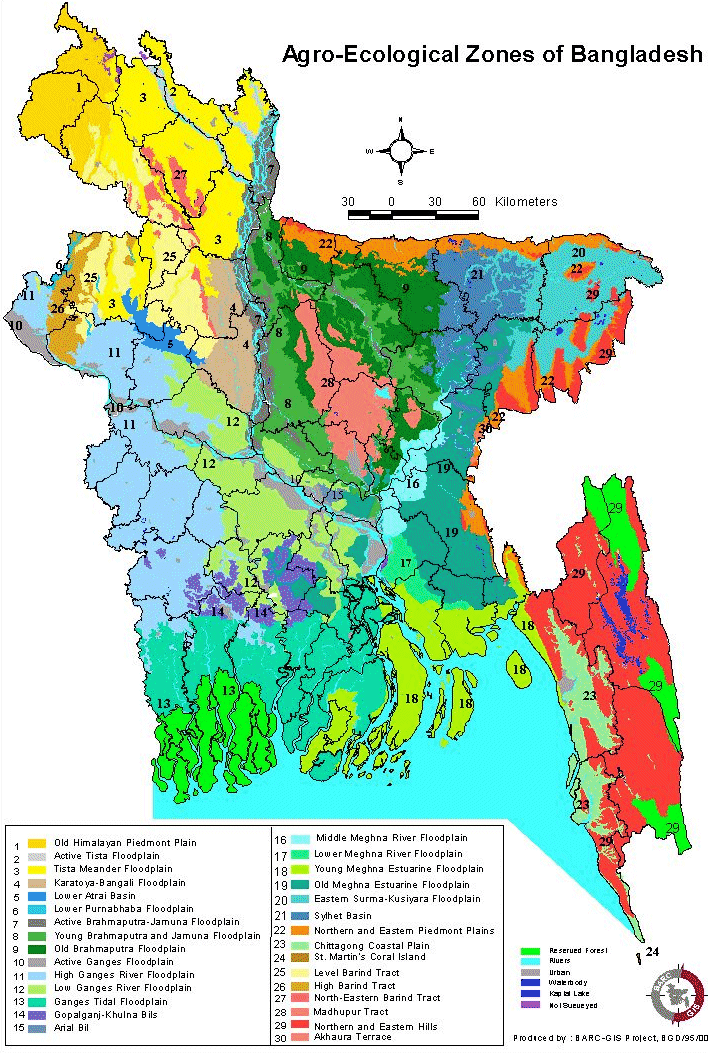
Mahananda floodplains. Agro-ecologically
the Barind Tract is divided into three
regions Level Barind Tract, High Barind
Tract and Northeastern Barind Tract.
Level Barind
Tract
The Level Barind Tract occupies about
65 per cent of the entire Barind Tract.
Its boundaries with other Barind Tract
regions are transitional. Located
in Dinajpur, Gaibanda, Jaipurhat,
Bogra, Nogaon, Natore and Sirajganj
districts, this tract covers an area
of 5,049 km2. Two subregions depending
upon the depth of flooding have been
recognized Highland and Medium Highland;
Medium Lowland and Lowland. Although
the landscape appears flat, there
are slight differences in elevation
between the higher parts on which
villages are located and the slight
depressions lying between them. Relief
is locally irregular near the entrance
of river channels, with shallow gullies
cutting back into the adjoining plain
land. In the West, elevations gradually
increase as this region merges with
the High Barind Tract. The region
is seasonally flooded within field
bunds. The whole of the level landscape
is poorly drained in the rainy season.
The Grey Terrace
soils are characteristic of the Barind
Tract. The predominant soils have
a grey, silty, puddled topsoil and
plough-pan. All soils become very
dry in the surface layer during the
dry season.
The mean annual rainfall
is highest in the northeast (2,000
mm) and lowest in the southwest (1,300
to 1,500 mm). Very small amounts of
surface water are available in rivers
and tanks for dry season irrigation.
Transplanted aman is the major kharif
crop. It is widely preceded by broadcast
or transplanted aus in the East and
North. Non irrigated land generally
remains fallow in the dry season.
Early rabi crops are grown where irrigation
is available.
High Barind Tract
The High Barind Tract was previously
termed the Dissected Barind Tract.
It includes the western part of the
Barind Tract where the underlying
Madhupur Clay has been uplifted and
cut into deep valleys. It occupies
about 20 per cent of the Barind Tract.
The western and southern boundaries
of the region are sharp, but the eastern
boundary is transitional. The High
Barind Tract is located in Rajshahi,
Nawabganj and Nogaon districts and
covers an area of 1,600 km2. Virtually
all the land stands above normal flooding
level. Terracing of sloping land during
the past two centuries to hold rainwater
on the soil surface for paddy cultivation
has greatly reduced the rate of run
off. Despite the sloping relief, this
region has predominantly poorly drained
grey soils with silty topsoil similar
to those occurring on the Level Barind
Tract. The region lies in the driest
part of the country and is semi arid
in character. The mean annual rainfall
is about 1,350 mm. Limited surface
water supplies are available in tanks.
Groundwater supplies are generally
poor in the more hilly western part.
The predominant land use is transplanted
aman grown as a single crop during
the rainy season. The rest of the
year is arid and basically crop less.
Development prospects are more restricted
than on the Level Barind Tract.
Northeastern Barind Tract
The Northeastern Barind Tract occupies
about 15 per cent of the Tract in
several discontinuous areas on the
northern and eastern margins. The
boundaries with adjoining floodplain
regions are mainly sharp, but are
transitional with those of the adjoining
areas of the Level Barind Tract. The
region is located in Dinajpur, Rangpur,
Gaibanda, Jaipurhat and Bogra districts
and covers an area of 1,079 km2. This
is the only part of the Barind Tract
which has red soils similar to those
of the Madhupur Tract. Three sub-regions
have been recognized, separating areas
with different proportions of well
drained, moderately well drained and
poorly drained soils. Most of this
region is better drained than the
adjoining land on the Level Barind
Tract and in floodplain regions. The
region is shallowly flooded in the
rainy season. A few valleys are seasonally
deeply flooded and their lower parts
remain wet or submerged throughout
the dry season. The mean annual rainfall
is highest in the northeast (about
2,000 mm) and decreases to around
1,800 mm in western and southern areas.
Surface water supplies
are limited to those in tanks and
a few beels. Groundwater is readily
available in the major area in the
northeast and is widely exploited
by dug wells and tube wells. Field
crops include sugarcane, aus rice,
mustard, black gram (mashkalai); with
irrigation, potatoes, vegetables,
wheat are grown in addition to rain
fed aus paddy.
Evidence of desertification
is noticeable in the dry and bare
soil conditions on the Barind Tract
during the prolonged dry season. The
Barind Tract is considered as an ecologically
fragile zone with extremely low vegetation
cover. It has practically no tree
cover except in the homesteads. Its
organic matter content of the soils
is very low. During high summer temperatures,
the moisture holding capacity of the
silty top soils especially when paddled
for paddy cultivation is low. Puddling
of soils for paddy cultivation in
the Kharif season leaves the topsoil
dry and hard or powdery in the dry
season and therefore, bare even of
weed growth. Powdery topsoil is blown
away during the dry season.
Breaking up the existing
plough-pan in Grey Terrace and Valley
Soils to allow deeper rooting could
destroy their bearing capacity when
wet, turning them into a bottomless
quagmire in the rainy season and a
hard, solid mass in the dry season.
Low moisture holding capacity, low
organic matter content and low natural
fertility of the major soils limit
the development potential of the Barind
Tract for maximizing crop production.
The abstraction of
groundwater for irrigation is already
drawing down dry season water levels
in some areas below the operational
level of dug wells and DTWs used to
provide domestic water. This problem
is likely to aggravate as tube well
irrigation extends and becomes more
intensive. In an effort to attain
food self sufficiency in the dry land
of the Barind Tract, attempts to substitute
dry-land crops for paddy cultivation
could destabilize the Barind soils.
Madhupur
Tract
The Madhupur Tract extends over the
districts of Dhaka, Gazipur, Narsingdi,
Narayanganj, Tangail, Jamalpur, Mymensingh
and Kishoreganj covering an area of
4,244 km2. The boundaries between
this region and adjoining regions
generally are sharp. However, they
are transitional in the Southwest
and parts of the Southeast where floodplain
sediments have buried the dissected
edges of the Madhupur Tract, leaving
small hillocks of red soils as `islands'
surrounded by floodplain soils. Three
kinds of valley systems dissect this
tract, giving rise to significant
differences in relief and soils. The
following 6 sub-regions are recognized:
Level terrace with deep, well drained
soils
These are level upland areas with
deep, mainly well drained and moderately
well drained, red and brown soils.
There are few or no valleys.
Dissected terrace with deep, well
drained soils
Closely dissected upland areas with
deep well drained red soils on level
upland sites, and deep, broad valleys
with mainly grey and dark grey heavy
clays.
Dissected terrace with shallow soils
and narrow valleys
Closely dissected areas with shallow,
moderately well to poorly drained,
mainly brown soils on gently undulating
uplands, and mainly grey silty soils
in narrow, shallow valleys.
Climatic conditions are relatively
uniform over the Madhupur Tract. Mean
annual rainfall increases from around
2,000 mm in the south to more than
2,300 mm in the North. Eleven general
soil types occur in the region.
Only limited amounts
of surface water are available in
rivers and beels, and these are almost
fully exploited. Rivers in the south
are tidal in dry season, but they
are not saline. Groundwater is generally
available.
Upland areas are
mainly under poor coppice sal forest
or scrub grassland. Cultivated upland
soils grow poor crops of aus, mesta,
groundnut, mustard and mashkalai.
Valleys are used for transplanted
aus followed by transplanted aman.
With irrigation, HYV boro is followed
by transplanted aman.
In the level terrace
mainly rain fed aus followed by mashkalai
or mustard are grown with jackfruit
trees on field boundaries. Sugarcane,
kharif groundnut and mesta are locally
important. With irrigation, wheat,
potato, and rabi vegetables are the
main crops. Sal forests cover part
of the area. The lowest valley sites
remain under water, providing irrigation
water which is also used for fisheries.
The Madhupur Tract
has complex relief and soil patterns.
The broken relief makes it difficult
to provide irrigation channels. Upland
soils and Grey Valley Soils have low
moisture holding capacity and low
natural fertility. Red soils are strongly
phosphate fixing and appear to be
deficient in potash, zinc and sulphur.
Grey Terrace and Valley Soils have
low structural stability in the silty
topsoil and subsoil. Breaking up the
plough pan would cause loss of bearing
capacity when the soils are wet. The
sloping soils on upland edges are
vulnerable to erosion. Deep flooding
in broad valleys and flash floods
in valleys are common. All the cultivated
upland soils are already depleted
in organic matter and fertility due
to continued cultivation without adequate
return of organic matter and nutrients
to the soils.
These constraints
limit the potentials for agricultural
development and render the Madhupur
Tract an ecologically vulnerable region.
Over 70 per cent of the sal forest
area is either degraded or encroached.
The present land use in the forest
area is detrimental to ecological
stability. It encourages destruction
of the forest cover resulting in serious
ecological imbalance. The imperative
is to go for an environmentally sound
integrated land use planning for sustained
development of the entire Madhupur
Tract.
Hilly soils
These include a wide range of soils
developed over consolidated and unconsolidated
sandstones, siltstones and shales
which underlie the Northern and Eastern
Hills (and their outliers in neighbouring
physiographic units). They are mainly
excessively to moderately well drained,
strong brown or yellow-brown, friable,
sndy loams to sandy clay loams occuring
on steep slopes
The majority are
deep over soft or fragmented rock,
but shallow soils over hard rock or
ironpan (laterite) occur locally.
On the level or rounded summits of
some low hills there are redder soils
overlying a strongly red-mottled sub-stratum.
Almost all hill soils
are strongly to extremely acid, moderately
to rapidly permeable and low in moisture
holding capacity. Organic matter contents
are moderate (locally high) under
old forest, but generally are low
in soils that have been repeatedly
used for shifting (jhum) cultivation.
The agricultural
potential of most hill soils is severely
limited by the steep slopes on which
they occur, aggravated by the heavy
monsoon rainfall and depleted soil
fertility resulting from repeated
jhum cultivation. They are best suited
for tree crops or forest production.
Terracing for the cultivation of field
crops would be impractical on most
soils because of the lack of suitable
materials for making retaining walls
and the risk of introducing landslip
erosion.
Char land
In Bangladesh newly accreted land
in the form of mid-channel bar in
the braided river course are called
char lands. The soils of these char
lands have predominance of sand deposits.
The Brahmaputra-Jamuna course in Bangladesh
has length of about 266 km and an
average width of 11 to 13 km. The
char areas in this river course are
virtually conglomerations of sandy
islands and some of these islands
are quite big and has habitation and
are cultivated.
The region has an
irregular relief of broad and narrow
ridges and depressions, interrupted
by cut-off channels and active channels.
Both the outline and relief of char
formations are subjected to change
each flood season due to bank erosion
by shifting channels and to depositions
of irregular thickness of new alluvium.
Local differences in elevation ranges
from 2 to 5 meters. In recent FAP
studies such char areas have been
grouped as active flood plain areas.
Coastal areas
The coastal ecosystem of Bangladesh
consists of the complex delta of the
Ganges Brahmaputra Meghna (GBM) river
systems. The systems while flowing
through Bangladesh on its way to Bay
of Bengal, carry an estimated annual
sediment load of 1.5 1.8 billion tons.
These sediments are subjected to coastal
dynamic processes generated mainly
by river flow, tide and wind actions,
leading to accretion and erosion in
the coastal area.
The coastal morphology
of Bangladesh is characterized by:
(a) A vast network of rivers;
(b) An enormous discharge of river
water heavily laden with sediments
both suspended and bed load;
(c) A large number of islands in between
the channels;
(d) The Swatch of No Ground (a submarine
canyon) running NE SE partially across
the continental shelf about 24 km
south of the Bangladesh coast;
(e) A funnel shaped and shallow northern
Bay of Bengal, to the north of which
the coastal area of Bangladesh is
located;
(f) Strong tidal and wind actions;
(g) Tropical cyclones and their associated
storm surges.
The entire coast
is about 710 km long and can be broadly
divided into three distinct physical
regions: the eastern, central and
western regions. The soils in the
eastern and central parts are grey
to silty clay loam, and in the western
region the soils are grey to dark
grey silty clay to clay. They are
saline.